Nebraska Broadband Map

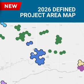
Navigating the Defined Project Areas (DPA) Map
- All DPAs have a unique color.
- DPA Tiers can be identified by their border.
- Tier 1 DPAs are displayed with bold borders.
- Tier 2 DPAs are displayed without bold borders.
- Tier 3 locations are not displayed as a DPA but individual locations.
- All Tier 3 locations have been included in DPA-Z1.
- Please download the listing below.
- NTIA-designated High-Cost Area locations are included in DPA-HC1.
- Tribal land locations are included in DPA-TR1 and DPA-TR2.
- Community Anchor Institutions (CAIs) are identified by square points.
- CAI type can be identified by the color of the icon:
- Purple represents a Community Support Organization.
- Orange represents a Public Safety Entity.
- Blue represents a Healthcare Entity.
- Green represents a Public Housing Organization.
Download complete DPA, BSL & CAIs (not included in a DPA) information
Browser Issues
To comply with the licensing restrictions of the location data, this site requires cross-site features to be enabled. If you receive a prompt to "Sign in" when loading the map try changing the settings in your browser to disable the "Prevent cross-site tracking" option by going to Settings and then Privacy.